Publications
2026
-
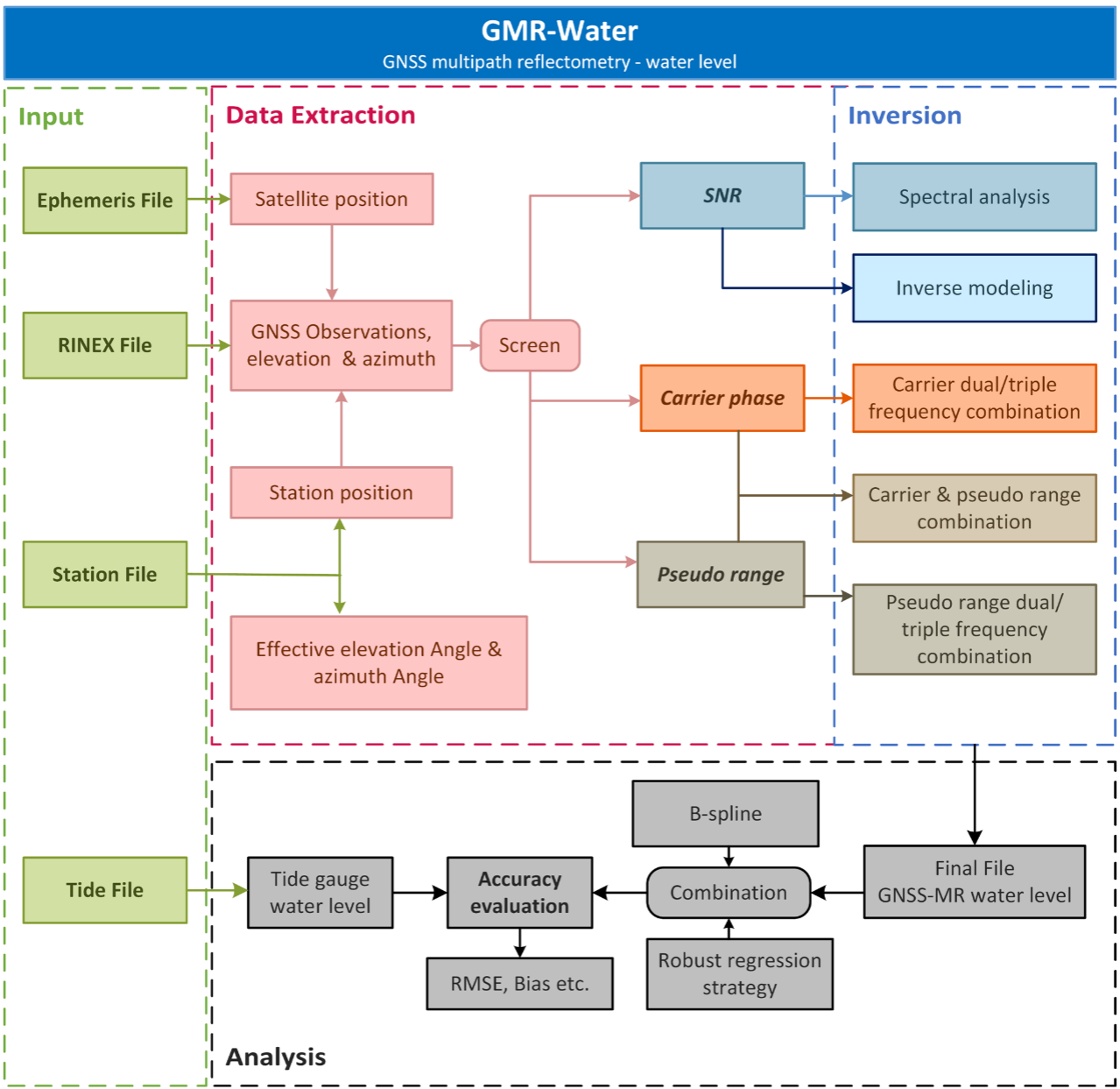 GMR-water: a water level retrieval software for multi-GNSS, multi-frequence and multi-observation based on GNSS-MRFei Yang and Ruixian HaoGPS Solutions, 2026
Monitoring coastal sea levels is crucial for assessing the impacts of climate change and predicting flood risks. In this context, GNSS-Multipath Reflectometry (GNSS-MR) has emerged as a promising technique, offering an efficient and stable method for sea level retrieval. To fully realize the ability of various GNSS observations in GNSS-MR for the water level inversion, the GMR-Water, an open-source MATLAB-based software, has been developed which is capable of efficiently using the multi-observations including Signal-to-Noise Ratio (SNR), carrier phase, and pseudo range. Moreover, the GMR-Water supports the integration of multi-GNSS, multi-frequency, and multi-observation data, employing advanced error correction and combination algorithms to ensure high-precision retrieval of water levels. The software is designed with a user-friendly interface, equipped with batch processing capabilities. and it offers a comprehensive set of visualization tools to enhance the interpretation of results. We validated the performance of GMR-Water using observational data from the AT01 GNSS station, where the software was used to process the GNSS observation and analyze the water level measurement. The results demonstrate that GMR-Water can effectively retrieve water levels with high accuracy, achieving consistent and reliable results across various GNSS observation types. The performance of GMR-Water proves its potential as a valuable tool for precise coastal sea level monitoring, contributing to the further development and application of GNSS-MR water level monitoring technology.
-
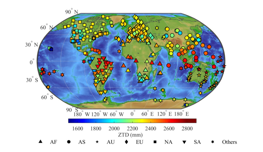 Calculation and evaluation of ZTD based on ensemble forecast data and AI-based weather model from ECMWFFei Yang, Kaiwen Xu, Ruixian Hao, and 4 more authorsGeodesy and Geodynamics, 2026
Accurate estimation and forecasting of zenith tropospheric delay (ZTD) are vital for satellite Earth observation, atmospheric monitoring, and meteorological applications. Ensemble forecasts could provide relevant atmospheric parameters that can be used for ZTD forecasting, but achieving high-accuracy, real-time ZTD prediction remains challenging due to the uncertainty of the initial conditions and the model resolution. With the development of large-scale models, artificial intelligence-based (AI-based) weather models also provide these parameters for ZTD forecasting with enhanced computational efficiency. A real-time calculation and comparative evaluation of high-accuracy ZTD forecasts was conducted, in which the prediction methods based on the ensemble and AI-based forecasts, i.e., ECMWF-IFS and ECMWF-AIFS, were compared in detail. Using global IGS-ZTD as a reference, ECMWF-AIFS demonstrated superior error distribution characteristics compared to the widespread systematic overestimation of ECMWF-IFS, achieving a regression slope of 0.995 versus 0.992. Spatially, ECMWF-AIFS significantly optimized global consistency by concentrating RMSE within the 0-15 mm range, effectively mitigating error fluctuations in low-latitude and equatorial regions. Temporally, both types of data maintained continuous and stable forecast capabilities throughout the 15-day forecast cycle; ECMWF-IFS maintained an RMSE below 30 mm during the first 6 days, while ECMWF-AIFS improved initial forecast accuracy by 35.2% and controlled the RMSE at 38.73 mm even on Day 15. In complex tropical coastal environments characterized by high water vapor variability, ECMWF-AIFS exhibited exceptional robustness, reducing the RMSE to 17.58 mm. These results indicate that AI-based weather models can effectively suppress error accumulation and correct systematic biases, demonstrating significant potential for real-time, high-precision tropospheric delay forecasting.
-
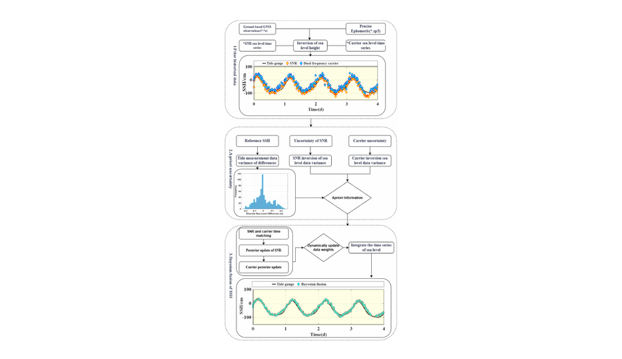 A fusion method of GNSS-IR sea surface height using the carrier and SNRFei Yang, Weicong Chen, Ruixian Hao, and 3 more authorsIEEE Journal of Selected Topics in Applied Earth Observations and Remote Sensing, 2026
Sea surface height (SSH) can be retrieved from reflected signals of global navigation satellite systems using the interferometric reflectometry technique, in which the signal-to-noise ratio (SNR) and the carrier phase could be utilized for this inversion. How to combine them to improve the accuracy of the SSH inversion remains a key research focus, therefore, this study proposes a Bayesian-based multi-source data fusion framework that effectively combines SNR and dual-frequency carrier phase. The experiment was conducted at station AT01 in Alaska, USA, using SNR signals of S5Q and S7Q and carrier phase of L5Q and L7Q from the Galileo satellite navigation system. Three types of combinations were employed in the Bayesian fusion, including Fused-1 combining S5Q and L5Q-L7Q, Fused-2 combining S7Q and L5Q-L7Q, and Fused-3 combining S5Q, S7Q, and L5Q-L7Q. Numerical results show that single inversions with S5Q, S7Q, and L5Q-L7Q yield RMSEs of 19.83, 19.45, and 19.50 cm, respectively, while the proposed fusion method greatly improves accuracy. Specifically, the RMSE are 10.79, 11.29, and 9.23 cm for Fused-1, Fused-2, and Fused-3, respectively. The residual and Bland-Altman analyses also show that the proposed fusion method has a better performance in terms of consistency and bias. The statistics of daily RMSE show that the proposed fusion method can effectively solve the problem of large fluctuations in single signal inversion, and can stabilize the fluctuation between 5 and 15 cm. Moreover, the proposed fusion method still achieved good results in special scenarios of flood and ebb tide. Experiments at the SC02 station demonstrate the effectiveness of the proposed method even when the single inversion already achieves high accuracy.
-
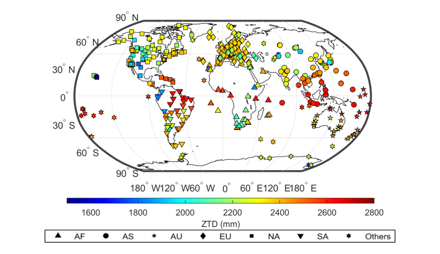 How to predict the zenith tropospheric delay (ZTD): using the ensemble forecast data from different NWPKaiwen Xu, Fei Yang, Lv Zhou, and 4 more authorsAdvances in Space Research, 2026
Tropospheric delay is a major source of error affecting the accuracy of satellite earth observation, including global navigation satellite system (GNSS). The accurate zenith tropospheric delay (ZTD) prediction is significant for positioning and navigation. This study proposed a method for predicting ZTD using meteorological ensemble forecast data and analyzed the performances of the ensemble forecast data from different NWP systems. The ZTD observations from IGS stations were used as references, and the ensemble forecast data from two high-resolution NWP systems, ECMWF-IFS and NCEP-GFS, were selected to conduct experiments to analyze their specific performance in ZTD prediction.
2025
-
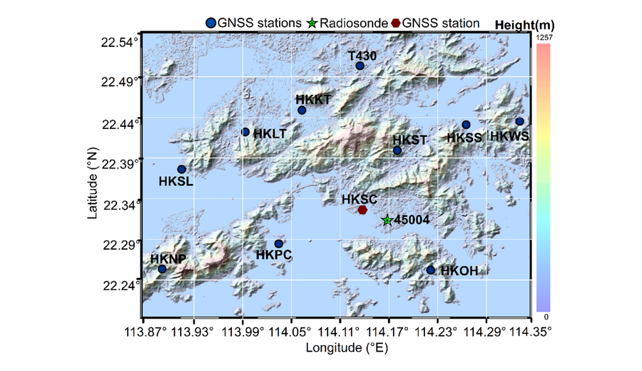 An optimal method for GNSS water vapor tomography based on parameter adaptationFei Yang, Ruixian Hao, Haoyu Wang, and 5 more authorsGPS Solutions, 2025
Precipitable water vapor (PWV) reflects the vertically integrated amount of water vapor in the atmosphere, but it only represents the two-dimensional distribution of water vapor. With the development of GNSS satellite constellation and station network, GNSS water vapor tomography has emerged as a prominent technique for obtaining the three-dimensional water vapor distribution and become a hotspot in GNSS meteorology. We propose an optimal method for GNSS water vapor tomography based on parameter adaptation to solve the ill-posed problem caused by the discretization parameter redundancy in the tomographic model. This method introduces the minimum probability factor of voxels being penetrated by signals, determines the number and position of the redundant parameters in the observation equation by iterating the coefficient matrix, establishes the optimal tomographic model by eliminating the zero elements of the coefficient matrix and the redundant parameters, and calculates the water vapor density of all voxels by constructing a Laplace smoothing equation. The tomography experiments conducted in Hong Kong show that the average root mean square error (RMSE) and mean absolute error (MAE) for the proposed and traditional method are 1.25/0.70 and 1.83/0.92 mm in the internal accurate testing, respectively, compared to the GAMIT-estimated slant water vapor (SWV) as a reference. The average RMSE and normalized RMSE are 10.9 mm and 8.2% for the proposed method, while these values are 13.2 mm and 10% for the traditional method. Using the radiosonde data as references, the proposed method improves average RMSE and MAE by 20.4% and 25.3% compared with the traditional method.
-
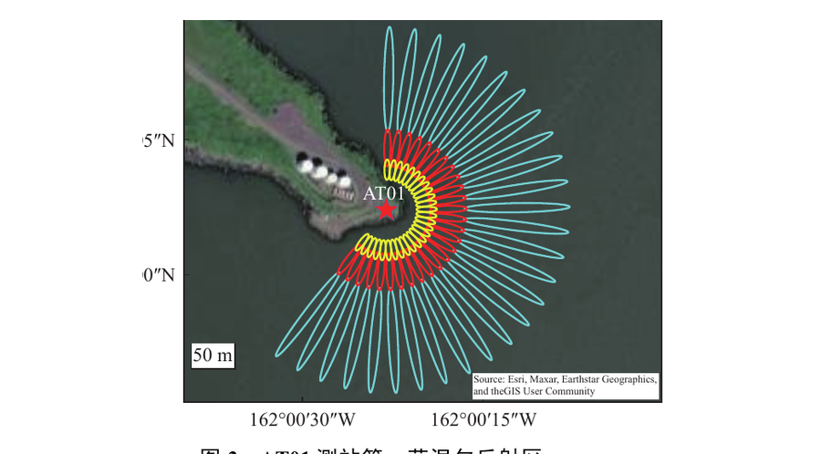 地基北斗多信息海面高反射测量方法及精度分析Ruixian Hao, Fei Yang, Weicong Chen, and 4 more authors全球定位系统, 2025
随着北斗卫星导航系统(BDS)的不断发展,基于 BDS 干涉反射测量(BDS-IR)的海面高反演受到了越来越多的关注。本文介绍了基于 BDS 信噪比(SNR)信号、载波相位三频组合以及载波伪距单频组合的海面高反演方法,并分析了信号种类、信号频点对 BDS-IR 海面高反演的影响。基于 AT01 测站的 120 d BDS 观测数据反演结果表明,SNR 反演模型、载波相位三频组合反演模型与载波伪距单频组合反演模型的均方根误差分别为 0.199 m、0.189 m 和 0.204 m,偏差分别为 0.126 m、0.067 m 与 0.130 m。
-
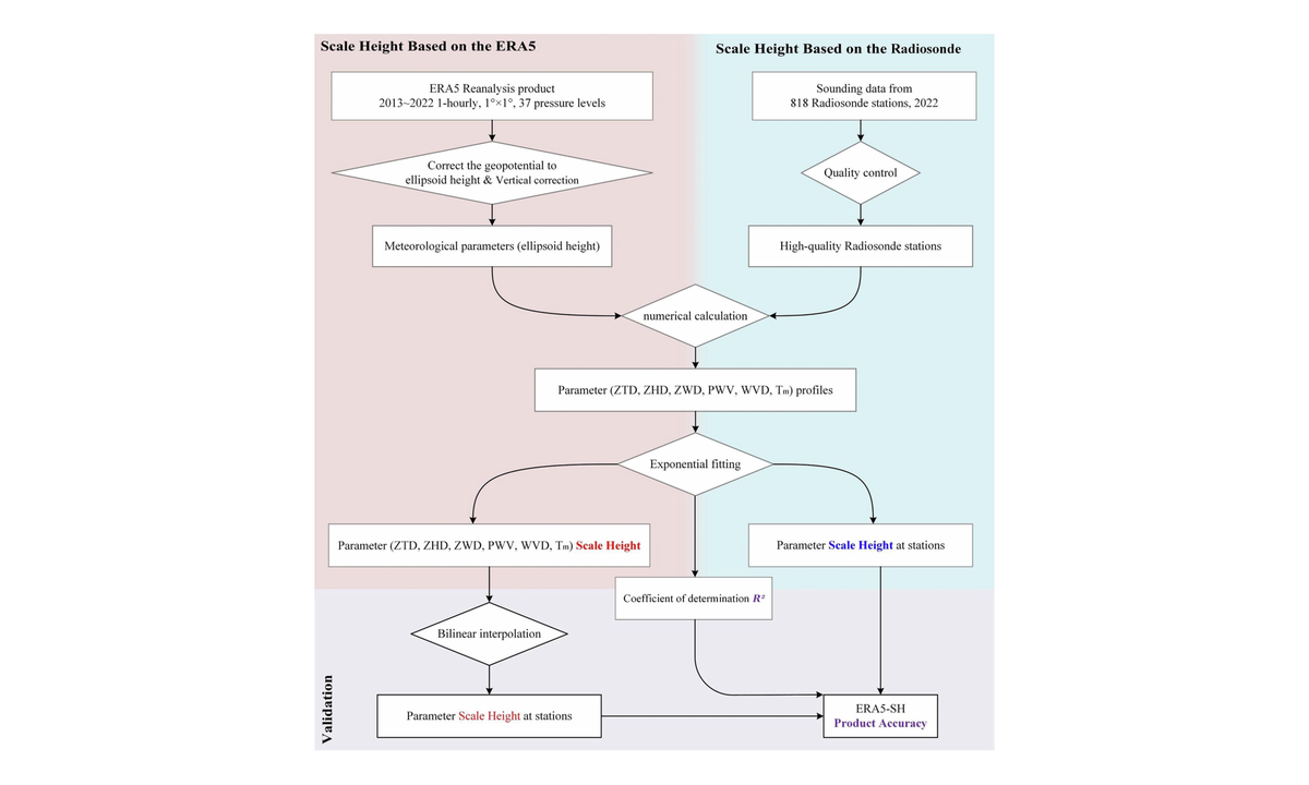 ERA5-SH: a global grided scale height dataset for tropospheric parameters based on ERA5 reanalysisRuixian Hao, Fei Yang, Zhicai Li, and 3 more authorsScientific Data, 2025
The scale height (SH) represents the height increment for a certain parameter to decrease to 36.7% (1/e) of its value at a certain height. Here we present ERA5-SH, a gridded dataset containing the SH values of six troposphere key parameters (PWV, WVD, Tm, ZTD, ZHD and ZWD) based on ERA5 reanalysis from 2013 to 2022, with a temporal resolution of 1 hour and a spatial resolution of 1 degree. The dataset was generated using numerical integral and exponential fitting, and exhibits high reliability with mean coefficients of determination being 0.991, 0.957, 0.980, 0.999, 0.999, and 0.995, respectively. Using the global distributed radiosonde sites as references, the mean RMSE for the six parameters were 0.243 km, 0.189 km, 3.290 km, 0.879 km, 0.681 km, and 0.263 km, respectively. This dataset will contribute to a deeper understanding of the tropospheric vertical distribution and to improve the accuracy of atmospheric delay modeling, which are vital for the advancement of the Earth observation technologies with high precision.
-
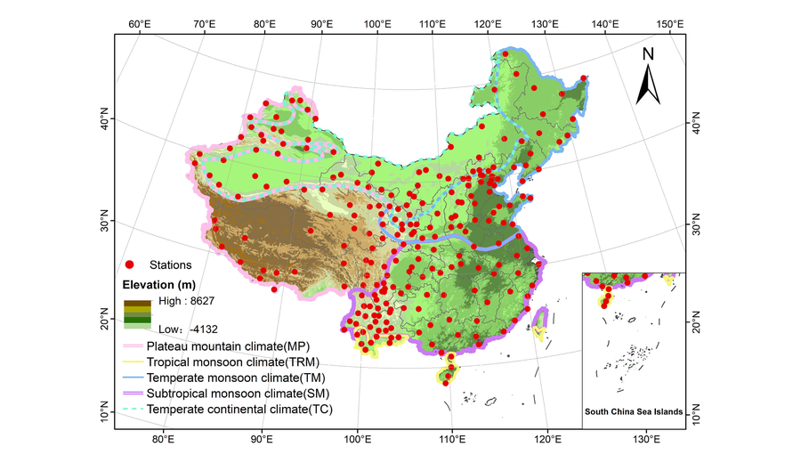 Spatio-temporal evaluation of tropospheric delay products in China using CMONOC data as referenceZhuoyue Wen, Fei Yang, Jian Li, and 3 more authorsAdvances in Space Research, 2025
The delay of the neutral atmosphere to the Global Navigation Satellite System (GNSS) signal, often expressed as the zenith tropospheric delay (ZTD), is critical to the accuracy and convergence time of GNSS positioning and is the basis for precipitable water inversion in GNSS meteorology. The study explored the performance of products with different spatial resolutions in estimating ZTD. In order to evaluate the accuracy of the ZTD values of the TUW-VMF3 and GFZ-VMF3 products in China region, this paper selects the hourly ZTD values as the estimated ZTD values and makes a comprehensive comparison with the ZTD values of 238 GNSS stations in the existing ZTD data of CMONOC for the period of 2012-2020 as a reference. In this process, particular attention is given to products with varying spatial resolutions to ensure the comprehensiveness and accuracy of the assessment results. The TUW-VMF3 outperformed the GFZ-VMF3 at 89.1% of the stations, but noted that the RMSE difference between the two was very small.
2024
-
 Comparing discrete and empirical troposphere delay models: a global IGS-based evaluationYifan Yao, Fei Yang, Jian Li, and 4 more authorsRadio Science, 2024
Zenith tropospheric delay (ZTD) is an important atmospheric parameter in radio-space-geodetic techniques such as Global Navigation Satellite System (GNSS), which is pivotal for GNSS positioning, navigation and meteorology. The Vienna Mapping Function (VMF) data server is a widely utilized source for implementing ZTD, offering two types of models, that is, the empirical one and the discrete one with Grid-wise and Site-wise models. Therefore, to evaluate the accuracy of these models becomes the focus of this article. Specifically, this study investigates their performances in terms of calculation of ZTD, using the hourly values derived from the International GNSS Service data as references. The results show that the root mean square err (RMSE) of the Site-wise, Grid-wise and global pressure and temperature 3 model are 11.71/13.03/38.56 mm, respectively, indicating the discrete model performs generally better than the empirical model, and the Site-wise model is the better of the two discrete models. From the perspective of spatial resolution, the performance of these three models in ZTD calculation shows obvious influences of latitude changes and elevation differences. From the temporal analysis, the accuracy of the discrete model shows differences over different UTC epochs, while the empirical model can only express the seasonal ZTD characteristics with the average RMSE at different epochs being similar, the specifically values are 39.67, 39.26, 39.38 and 39.18 mm at UTC 0:00, 6:00, 12:00 and 18:00, respectively. The histogram and boxplot well indicate the accuracy differences of the three models in different seasons. Additionally, the time series of three models at different latitudes were also explored in this research. These explorations are conducive to the selection of appropriate models for calculating ZTD based on specific requirements.
-
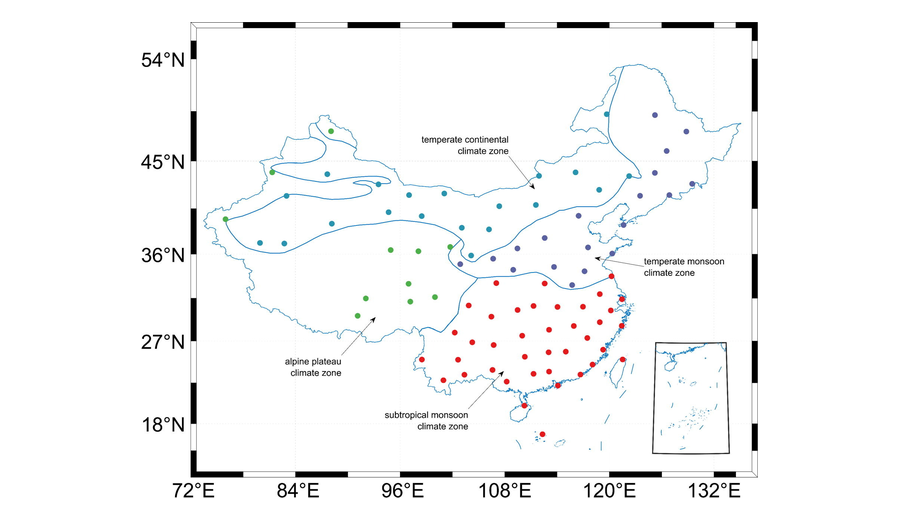 Spatial-temporal variation of water vapor scale height and its impact factors in different climate zones of ChinaRuixian Hao, Tairan Xu, Zhicai Li, and 5 more authorsAdvances in Space Research, 2024
Water vapor scale height reflects the vertical distribution of water vapor in the atmosphere, which is a vital parameter in tropospheric zenith wet delay (ZWD) modeling and GNSS meteorology. This study accurately calculated the long-term water vapor scale height using 89 radiosonde stations in China, analyzed the characteristics in temporal and spatial variations and explored the impact factors of the water vapor scale height from the perspective of the climate zones. The numerical results indicate that the water vapor scale height in China exhibits annual and semiannual variations with a rising-then-decreasing trend across the four seasons. A relatively larger value for the water vapor scale height were observed in the subtropical monsoon climate and the temperate continental climate zone, in which the values are greater than 2.35 km, while the values in temperate monsoon climate and the alpine plateau climate zone are relatively small. In addition, the water vapor scale height in different climate zones shows different trends, with a downward trend appeared in the subtropical monsoon climate and the alpine plateau climate zone, while an upward trend was observed in the temperate monsoon climate and the temperate continental climate zone. Furthermore, a positive correlation between water vapor scale height and temperature, pressure, and atmospheric precipitable water was found in China, with a varied degree of correlation in different climate zones.
2023
-
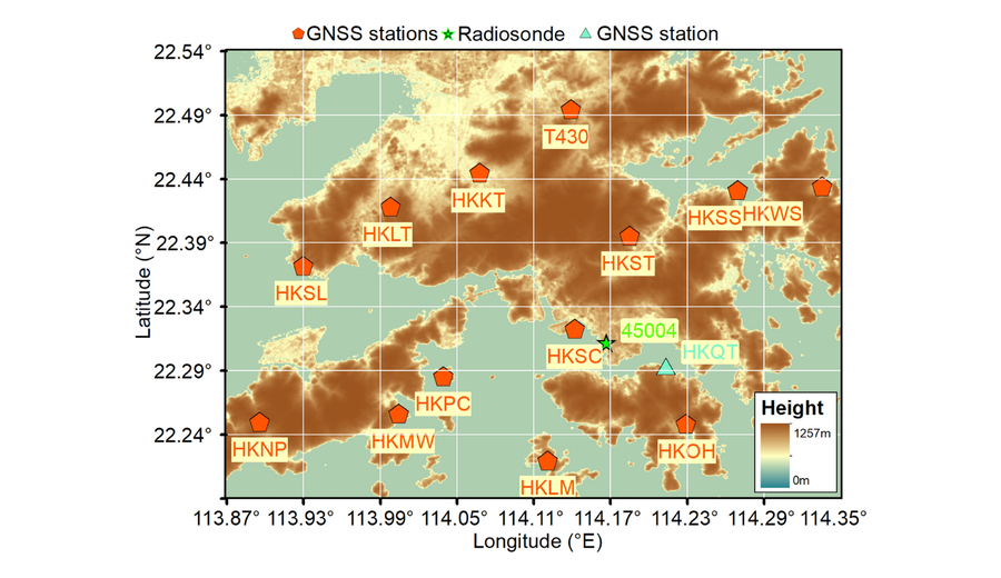 GNSS water vapor tomography based on Kalman filter with optimized noise covarianceFei Yang, Xu Gong, Yingying Wang, and 4 more authorsGPS Solutions, 2023
GNSS water vapor tomography has emerged as a prominent technique for obtaining the three-dimensional distribution of atmospheric water vapor. It effectively compensates for the deficiency of GNSS precipitable water vapor that only reflects the two-dimensional distribution of water vapor and has become a hotspot in GNSS meteorology. The GNSS water vapor tomography based on the Kalman filter well considers the correlation between successive epochs and avoids the restrictions of too many additional constraints, but its accuracy and stability are often affected by the noise covariance. We propose an optimized noise covariance matrix method for GNSS water vapor tomography based on the Kalman filter. It constructs the state noise covariance using historical water vapor information derived from atmospheric reanalysis data and establishes the observation noise covariance considering the satellite elevation angle and the signal intercept crossing the tomographic voxels. The tomography experiments conducted in Hong Kong show that the root-mean-square error (RMSE) and mean absolute error (MAE) of the slant water vapor computed by the proposed method decreased by 38.8% and 34.9% compared with the traditional method. The proposed method improves average RMSE and MAE of 23.2% and 24.8% compared to the radiosonde data and 27.6% and 44.3% compared to ERA5 data.